Palmer LTER Research Overview
Investigations at the Palmer LTER site include:
- Physical forcing (solar, atmospheric, oceanic and sea ice) with emphasis on ecological consequences of annual and inter-annual variation
- Ecology and population biology of marine bacteria and archaeal, phytoplankton, zooplankton and seabirds
- Biogeochemical cycling of carbon and nitrogen
- Ecosystem responses to climate migration
- Physical/chemical/biological modeling linking ecosystem processes to environmental forcing
Testable hypotheses link sea ice advance, retreat and extent to carbon and oxygen dynamics, seasonal primary production, zooplankton abundance, distribution and recruitment; foraging, breeding success and survival of apex predators such as Adélie penguins; and large-scale interactions of the atmosphere and ocean. Our research emphasizes regular annual sampling of a grid of hydrographic stations along the west Antarctic Peninsula, oceanographic process studies, moored sediment traps, intensive seasonal studies in seabird colonies, moored and glider-based oceanographic sensors, remote sensing of ocean color, sea surface temperature and sea ice. Observations and experimental results are integrated and synthesized using one- and three-dimensional ocean process models.
Old Palmer Station was established in 1965 with the current Palmer Station occupied starting in 1967. The National Science Foundation Office of Polar Programs in collaboration with the Division of Environmental Biology designated Palmer in 1990 as the first polar biome LTER site in the Southern Hemisphere. Logistics support for all Antarctic activity of the United States is provided by Raytheon Polar Services.
Polar Ecology & Major Impacts
Our marine ecology of the Southern Ocean focus is within the Western Antarctic Peninsula area and includes: physical forcing with an emphasis on the ecological consequences of sea-ice variability, biological processes with an emphasis on microbial and primary production as well as life-history parameters of secondary producers (krill) and apex predators (penguins, seals) and modeling that links ecosystem processes to environmental variables.
Factors strongly influencing the flora and fauna of the Palmer LTER site include: low temperatures, a short growing season, high winds influencing the depth of the mixed layer, proximity to land with the potential for input of micronutrients, and varying snow and sea-ice coverage. Characteristics of the landscape-seascape of seawater, ice, snow and rock vary as the 24-hour darkness in June changes to 24-hour daylight in December. This so-called high-nutrient, low-biomass marine environment, sustains a few hundred grams of carbon/m2/year of primary production.

Methods
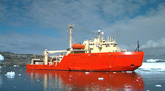
Participating scientists conduct field studies at Palmer Station from research vessels, zodiacs, laboratories and remote-sensing platforms such as satellites, weather stations and moorings. Further analysis and experiments are based at their home institutions. Scientists and technicians cruise on a research vessel each January to match the penguin nesting period and to take samples of the larger grid and penguin foraging areas.
From October through March to match the biologically active spring through summer months, smaller inflatable zodiac watercrafts based at Palmer Station sample hydrography, as well as near-shore abundance and distributions. These near-shore data help scientists place data gathered during the January cruise into a seasonal context of interannual variability. Data from satellite-borne instruments combined with insitu measurements provide significant and reliable long-term data.
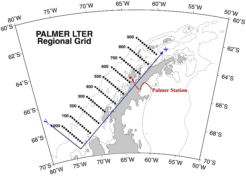
Sampling Grid
Standard measurements are taken at established stations within a series of nested grids. An oceanic sampling grid, which is 200km on/offshore, stretches 900km along shore roughly parallel to the Peninsula. This 180,000 sq km region surrounding Palmer Station reflects the regional scale of atmospheric, oceanic, and sea-ice interactions with populations in the marine ecosystem. Smaller embedded grids address local hydrography, near-shore primary and secondary production, and the foraging range of nesting seabirds. Elevation ranges from 10m on land to 2000m below sea surface.